PENNY
sales tax
Road Projects
2016-2020

NW 49th / 35th St.
phases 2B & 2C
A new four-lane roadway from NW 44th Ave. to the Ocala city limits, including an interchange at I-75. This will provide traffic-carrying capacity and enhance the opportunity for economic development in the area.
-
Length: 1.2 miles
-
Status: In progress

SW 49th / 40th Ave.
phases 1, 1A, 2, 3
A four-phased project that includes a new four-lane from SW 95th St. to SW 42nd St., boosting traffic capacity.
-
Length: 5 miles
-
Status: In progress

SW 49th Ave. South
segments A & E
A new four-lane roadway from 1.1 mile south of Highway 484 to Marion Oaks Trail. This project is another phase of SW 49th Ave. corridor.
-
Length: 1.5 miles
-
Status: In progress

NE CR 315
Rehabilitation from CR 316 to CR 318.
-
Length: 9.9 miles
-
Status: Complete

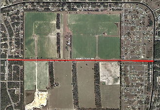
CR 484
Adding two lanes to Highway 484 from Marion Oaks Pass to Marion Oaks Course, improving traffic capacity and flow along this congested corridor.
-
Length: 1.5 miles
-
Status: Complete

NW Gainesville Road (CR 25A)
Rehabilitation from CR 329 to U.S. Highway 441.
-
Length: 5.2 miles
-
Status: Complete

CR 464B
Rehabilitation from the Levy County line to U.S. Highway 27.
-
Length: 7.1 miles
-
Status: Complete

S. Highway 314A
Rehabilitation from SE 95th St. Road to SE 24th St. Road.
-
Length: 5.5 miles
-
Status: Complete

SE 182nd Ave. Road
Rehabilitation from CR 42 to SE 95th St. Road.
-
Length: 7.6 miles
-
Status: Complete

Marion Oaks Blvd.
Rehabilitation from Marion Oaks Manor, between 56th Terrace Road and 56th Court, to Marion Oaks Manor, between 31st Court and SW 29th Court Road.
-
Length: 3.7 miles
-
Status: Complete

CR 316
Rehabilitation from CR 315 to west of the Eureka Bridge.
-
Length: 4 miles
-
Status: Complete

CR 326
Rehabilitation from the Levy County line to U.S. Highway 27.
-
Length: 4.1 miles
-
Status: Complete

CR 42
Rehabilitation from U.S. Highway 441 to CR 25.
-
Length: 3.7 miles
-
Status: Complete

Emerald Road
Rehabilitation from Maricamp Road, southwest to Oak Road.
-
Length: 1.1 miles
-
Status: Complete

CR 320
Rehabilitation from I-75 to U.S. Highway 441.
-
Length: 2.8 miles
-
Status: Complete

SW 107th Place (CR 475B)
Rehabilitation from CR 475A to CR 475.
-
Length: 1.1 miles
-
Status: Complete

SW 38th Ave.
Rehabilitation from SW 95th St. to SW 66th St.
-
Length: 3.11 miles
-
Status: Complete

Emerald Road Extension
A new two-lane roadway from SE 92nd Loop to the existing terminus at Florida Northern Railroad. This will create a continuous corridor from east Maricamp Road to SE 92nd Loop.
This new corridor will provide relief to the intersection of SE Maricamp Road and SE 58th Ave. as well as add traffic-carrying capacity for southeastern Marion County and Silver Springs Shores.
-
Length: 1.8 miles
-
Status: In progress

NW 80th Ave. / 70th Ave. Road
Design phase to add two lanes to NW 80th Ave. / 70th Ave. Road from State Road 40 to 0.5mi north of U.S. Highway 27.
-
Length: 4.2 miles
-
Status: In progress

NW / SW 80th Ave. at Highway 40
Road widening from 1300ft south of Highway 40 to 1500ft north of Highway 40, with signalization added at Highway 40.
-
Length: 0.8 miles
-
Status: In progress

NW 70th Ave. at U.S. Highway 27
Road widening from 1300ft south of U.S. Highway 27 to 1500ft north of U.S. Highway 27, with signalization added at U.S. Highway 27.
-
Length: 0.78 miles
-
Status: In progress
